
Some people, particularly those who have never visited Turkey, imagine it as a hot, dry country covered in deserts. While parts of Turkey have arid or semi-arid climates, the country as a whole is far from being a desert. In fact, approximately 30% of its land is covered by forests. Istanbul is even further from that stereotype. It is certainly not an Arab city surrounded by desert, as some might imagine. Istanbul has a humid climate, receives plenty of rain, particularly in autumn and winter, and experiences cold winters with occasional heavy snowfall.
The city also has an extensive network of streams, rivers, valleys, and watersheds. Just north of the urban center, Belgrad Forest (or Belgrade Forest) is home to numerous streams and several historic dams, some built centuries ago to collect water for the city. Water has always been an important part of Istanbul’s geography and history. So, while the recent rainfall was exceptional, the fact that Istanbul is vulnerable to flooding should hardly come as a surprise.
Istanbul’s devastating October 2026 floods
In mid-October 2026, Istanbul experienced one of the most severe rainstorms in its recent history. Torrential rainfall caused devastating floods across the city, turning streets into rivers, submerging roads and underpasses, flooding homes and businesses, and sweeping away vehicles. At least four people lost their lives, while emergency services struggled to respond to thousands of incidents across the city.
The amount of rainfall was extraordinary. According to data from the Turkish State Meteorological Service, compiled by Anadolu Agency, Istanbul received an average of 119.2 mm (millimeters) of rainfall in just 48 hours, between October 13 and 15, 2026.
To put that into perspective, Istanbul’s long-term average precipitation for September and October combined is approximately 106 mm. In other words, the city received more than two months’ worth of average rainfall in just two days.
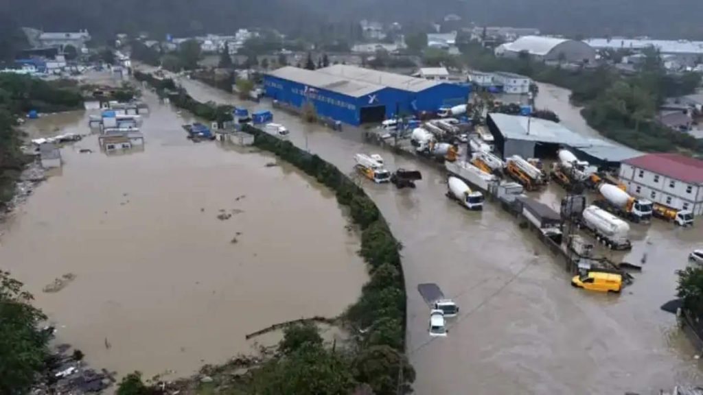
Some districts experienced even more extreme conditions. Beykoz recorded an astonishing 274.4 mm of rainfall, followed by Arnavutköy with 222.2 mm, Sarıyer with 208.3 mm, and Eyüpsultan with 203.3 mm. For comparison, Istanbul’s average annual precipitation is approximately 659 mm.
The consequences were devastating. The Istanbul Metropolitan Municipality reported more than 9,700 emergency calls and incident reports involving flooding, overflowing drains, road damage, stranded residents, and fallen trees.
However, while the intensity of this particular storm was exceptional, flooding in Istanbul is neither a new phenomenon nor an unexpected risk. The city has experienced devastating floods before, including the deadly September 2009 floods that claimed 32 lives.
Istanbul’s climate, geography, extensive network of streams, and decades of rapid urbanization all contribute to its vulnerability. Extreme rainfall may be unavoidable, but its consequences are strongly influenced by how a city is built and managed.
To understand why flooding is such a serious problem in Istanbul, we must first understand the city’s natural environment and how human activity has transformed it.
Istanbul is not a hot, dry desert city
Some people, particularly those who have never visited Turkey, imagine Istanbul as a hot, dry Middle Eastern city surrounded by deserts. Nothing could be further from the truth. Istanbul is located in northwestern Turkey, straddling Europe and Asia, between the Black Sea and the Sea of Marmara. Far from having a desert climate, the city has a temperate climate with cool, wet winters and warm, often humid summers.
According to the Turkish State Meteorological Service (MGM), Istanbul’s average temperature in January is approximately 6.8°C (44.2°F), while July and August average 24.7°C (76.5°F). Winter temperatures frequently drop close to freezing, and occasionally well below it.
Rainfall is a normal part of life in Istanbul, especially during autumn, winter, and spring. Based on official meteorological records from 1950 to 2025, the city receives precipitation on approximately 115 days per year. December is typically the wettest month, averaging 99.2 mm of precipitation, followed by January with 88.8 mm. Summers are considerably drier, although thunderstorms and occasional heavy downpours still occur.

Snowfall is another aspect of Istanbul’s climate that surprises many visitors. Snow can fall between December and March, although its frequency and intensity vary considerably from year to year. Some winters pass with little accumulation, while others bring heavy snowstorms that cover streets, parks, rooftops, and even the shores of the Bosphorus. In March 1987, official meteorological records documented a snow depth of 41 cm. More recently, the city experienced heavy snowfall in January 2017, as illustrated in photographs taken at Boğaziçi University.
Istanbul’s climate is therefore very different from the dry, desert-like conditions some people associate with Turkey. Rain and snow are familiar features of the city’s weather, not rare or unexpected events. And its climate is only part of the story: Istanbul also has an extensive natural network of streams, valleys, and watersheds that have shaped its landscape for centuries.

How much rain does Istanbul actually receive?
Istanbul receives considerably more precipitation than many people might expect. According to the Turkish State Meteorological Service (MGM), the city’s average annual precipitation is approximately 659 mm (26 inches), based on meteorological records from 1950 to 2025.
Interestingly, this is more than the annual rainfall recorded at some weather stations in London, a city famous for its rainy and gloomy weather. According to the UK’s Met Office, London’s Heathrow Airport receives approximately 615 mm annually, while Greenwich Observatory receives around 563 mm. Dublin Airport, in Ireland, records a higher annual average of approximately 773 mm.
However, precipitation is not distributed evenly across Istanbul. The city covers a large geographical area stretching from the Black Sea in the north to the Sea of Marmara in the south. According to a scientific study published in the journal Water, Istanbul’s northern watersheds, particularly those along the Black Sea coast on both the European and the Asian side, receive considerably more rainfall than its southern districts.
There is also another important distinction: annual precipitation and rainfall intensity are not the same thing. A city receiving 1,000 mm of rain spread relatively evenly throughout the year may experience fewer floods than a city receiving just 600 mm, much of it during a handful of intense storms.
For example, 100 mm of rainfall in just a few hours means that 100 liters of water fall on every square meter of ground. When such an enormous volume of water arrives faster than streams, soil, and drainage systems can accommodate it, severe flooding can occur.
This is why annual rainfall averages alone tell us relatively little about a city’s vulnerability to flash floods.
Istanbul has hundreds of streams and an extensive drainage network
One of the most overlooked aspects of Istanbul’s geography is its extensive network of streams, valleys, and drainage basins. Most visitors know the city for the Bosphorus, the Golden Horn, and the Sea of Marmara, but Istanbul’s waterways extend far beyond these famous landmarks. Beneath and between its densely populated neighborhoods lies a complicated natural drainage system that has developed over thousands of years.
According to the Istanbul Metropolitan Municipality, the Istanbul Water and Sewerage Administration (İSKİ) reported approximately 3,919 kilometers (2,435 miles) of streams and tributaries across Istanbul in August 2026. This enormous network includes waterways flowing through forests, agricultural land, and densely urbanized districts.
Among Istanbul’s best-known streams are Kağıthane Stream and Alibeyköy Stream, which flow into the Golden Horn, the historic estuary connected to the Bosphorus. On the European side, Ayamama Stream and Çırpıcı Stream carry water southward toward the Sea of Marmara. On the Asian side, Kurbağalıdere flows into Kalamış Bay, while Göksu Stream empties into the Bosphorus near the historic Anadolu Hisarı fortress. Farther north, Riva Stream flows through Beykoz and eventually reaches the Black Sea.
These streams exist because of Istanbul’s natural geography. The city is built across hills, plateaus, and valleys shaped by erosion over geological time. When rain falls, some water infiltrates the soil, some evaporates, and the remainder flows downhill as surface runoff. Small channels collect water from surrounding slopes and join larger streams, eventually carrying it toward the sea, lakes, or reservoirs.
The land area that collects and channels water into a particular stream is called a drainage basin, or watershed. Istanbul contains numerous interconnected stream systems, each with its own drainage basin. Some waterways flow throughout the year, while others are seasonal and may remain nearly dry during summer. However, even normally dry streambeds can carry substantial amounts of water during heavy rainfall.
This is particularly important for understanding Istanbul’s floods. A stream does not need to carry water throughout the year to become dangerous during a storm. When intense rainfall affects a drainage basin, enormous volumes of water can converge on the same valley or channel within a relatively short period.
What Happened to Istanbul’s Streams? Concrete, Construction, and Buried Waterways
Over the past several decades, Istanbul’s rapid urbanization has dramatically transformed its natural waterways. As the city’s population grew and residential, commercial, and industrial areas expanded, many streams were straightened, confined within concrete channels, or even buried underground. Roads, buildings, and industrial facilities were constructed along streambanks and on natural floodplains, often leaving little room for waterways to accommodate heavy rainfall.
Under natural conditions, streams can overflow onto their surrounding floodplains during periods of intense rainfall. These areas temporarily accommodate excess water, reducing the pressure on downstream channels. However, when streams are confined to narrow concrete channels or underground culverts, their capacity becomes limited by the dimensions of these structures. If the incoming water exceeds that capacity, flooding can occur rapidly.
Ayamama Stream, on Istanbul’s European side, is a particularly striking example. A 2016 scientific study published in Ecohydrology & Hydrobiology documented extensive modifications to the stream, including channelization, burial, and industrial development along its banks. According to the study, approximately 72% of the watershed was already covered by residential and industrial development, based on 2010 land-use data.
The consequences became tragically clear during the September 2009 floods, when Ayamama Stream overflowed following exceptionally heavy rainfall, causing widespread destruction and loss of life. A subsequent hydrological study identified extensive construction on the floodplain as a major contributor to the area’s flood vulnerability.
This does not mean that concrete channels are inherently harmful. Properly designed flood-control structures can protect surrounding neighborhoods. However, undersized channels, obstructed culverts, and construction within floodplains can substantially increase flood risks.
The fundamental problem is that urban development cannot eliminate a stream’s natural drainage basin. Even when a stream disappears beneath roads or buildings, rainwater continues to flow downhill toward the same low-lying areas. Covering a stream does not make the water disappear. Sooner or later, unusually intense storms can produce far more water than underground culverts and concrete channels were designed to carry.
When that happens, these structures can become overwhelmed, and the water may reclaim its natural course, flooding the roads, buildings, and neighborhoods constructed above or around it. It is not a question of whether such extreme rainfall is possible, but whether the city is prepared when it occurs.
Istanbul’s hills and valleys make some neighborhoods particularly vulnerable
Istanbul is famously known as the “City of Seven Hills,” but its hilly terrain extends far beyond the historic peninsula. Much of the metropolitan area consists of hills, ridges, and valleys, with elevations commonly reaching up to 250 meters above sea level. These natural features play an important role in determining how rainwater moves across the city and where flooding is most likely to occur.
When heavy rain falls on sloping terrain, water that cannot infiltrate the soil flows downhill under the influence of gravity. Small streams of runoff merge into larger flows, which eventually accumulate in valleys and other low-lying areas. The steeper the slope, the faster water can travel, potentially allowing large volumes of runoff to reach the bottom of a valley within a relatively short time.

This creates particular dangers in a densely populated city like Istanbul. Many roads, residential neighborhoods, and commercial areas have been built along natural valleys and former streambeds. Although urban development has dramatically altered the landscape, it has not eliminated the underlying topography. Rainwater still tends to accumulate in low-lying areas, even where natural waterways have been replaced by roads, buildings, or underground drainage systems.
Road underpasses, basement apartments, underground parking garages, and streets at the bottom of steep hills are particularly vulnerable. During intense rainfall, these locations can collect water rapidly, especially when drainage systems become overwhelmed. In some cases, roads themselves can act like artificial streams, directing fast-moving water downhill.
Another important point is that flooding does not necessarily occur where the heaviest rain falls. Water from an entire drainage basin can converge on a relatively small area, meaning neighborhoods downstream may experience severe flooding even when local rainfall is relatively moderate.
Istanbul’s geography, therefore, creates natural flood hazards that urban planning must account for. Hills and valleys are not inherently dangerous, but constructing buildings and infrastructure in natural drainage paths without adequately accommodating stormwater can turn an extreme rainfall event into a devastating disaster.
The concrete jungle: why rainwater can no longer soak into the ground
One of the most significant consequences of Istanbul’s rapid urbanization is the enormous expansion of concrete, asphalt, and other impermeable surfaces.
Over the past several decades, natural landscapes have been replaced by residential buildings, shopping centers, industrial facilities, roads, and parking lots. This transformation has fundamentally changed how rainwater moves across the city.
Under natural conditions, rainfall follows several different paths. Some water is intercepted by vegetation and eventually evaporates. Some infiltrates the soil, replenishing groundwater or moving slowly through the ground. The remainder becomes surface runoff, flowing downhill toward streams and rivers.
However, asphalt, concrete, and rooftops prevent most rainwater from infiltrating the ground. Instead, a much larger proportion becomes surface runoff, rapidly flowing into streets, storm drains, and waterways.
In urban hydrology, this is described using the concept of impervious surface area: the proportion of land covered by surfaces that prevent or severely restrict water infiltration. As this proportion increases, so does the potential for rapid surface runoff.

Importantly, urbanization does not merely increase the volume of runoff. It also reduces the time it takes for rainwater to reach streams and drainage systems. Water that would otherwise infiltrate the soil or move slowly across vegetated ground can reach drainage channels within minutes. Consequently, larger volumes of water may arrive almost simultaneously, producing higher peak flows and increasing flood risks.
This effect has been documented in Istanbul. A 2016 scientific study examining the Ayamama watershed found that scenarios involving extensive urbanization produced higher peak discharges and shorter times to peak flow.
Similarly, a 2021 study of the Kağıthane Stream watershed demonstrated through hydrological modeling that green roofs, permeable surfaces, and other green infrastructure could reduce runoff and flood risks.
Of course, natural soil cannot absorb unlimited amounts of water, particularly when already saturated. Nevertheless, replacing permeable landscapes with concrete and asphalt removes much of the ground’s natural ability to absorb and temporarily store rainfall.
In a city like Istanbul, where heavy rainfall is a normal part of the climate, this transformation can have serious consequences.
Deforestation: Istanbul’s Disappearing Natural Water-Regulation Systems
Istanbul’s northern forests are among the city’s most important natural assets. Stretching across large areas near the Black Sea, these forests contain numerous streams and watersheds, including those feeding major drinking-water reservoirs such as Terkos (Durusu) and Ömerli. Beyond providing habitats for wildlife and helping protect water quality, forests play an important role in regulating how rainfall moves through the landscape.
When rain falls on a forest, some of it is intercepted by leaves and branches, temporarily preventing it from reaching the ground. Some of this water evaporates back into the atmosphere. Water reaching the forest floor can infiltrate the soil, where organic matter, roots, and other biological activity help create spaces for water storage and movement. Trees also absorb water through their roots and release it into the atmosphere through transpiration.
Together, these processes can reduce surface runoff and slow water movement toward streams and rivers, particularly during smaller rainfall events.
Unfortunately, urban expansion and major infrastructure projects, including Istanbul Airport, the Northern Marmara Motorway, and the Yavuz Sultan Selim Bridge, have caused extensive damage to Istanbul’s northern forests.
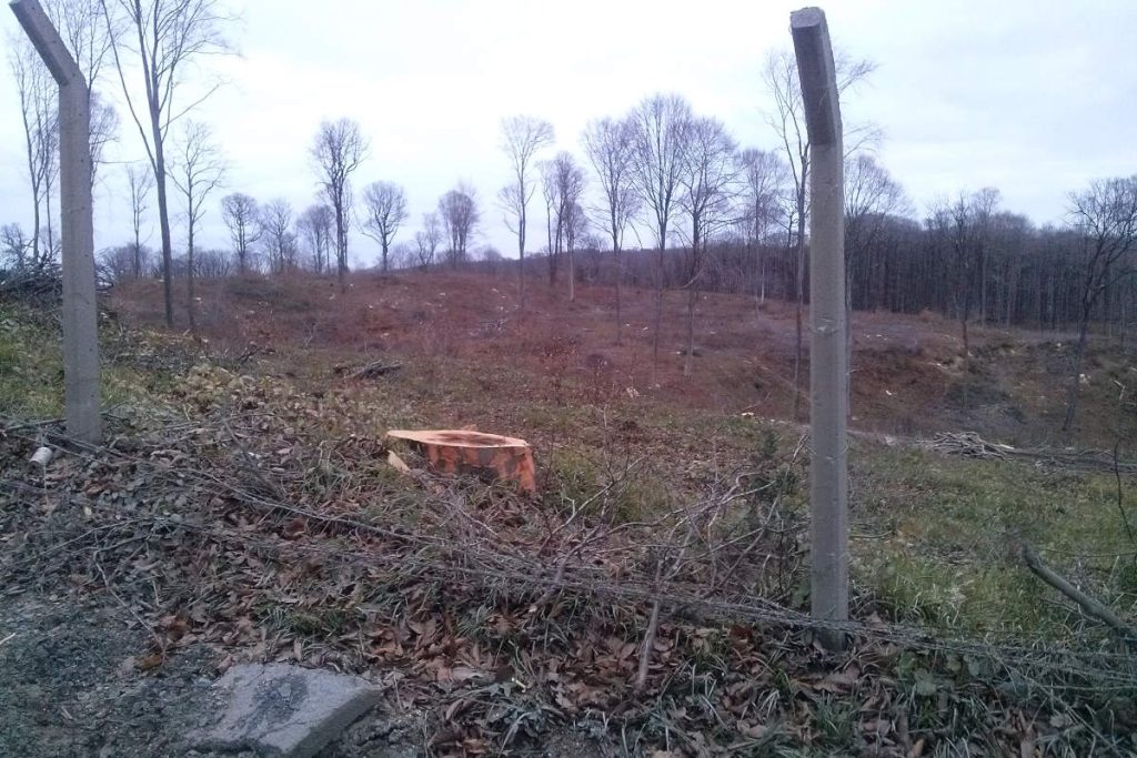
A 2020 scientific study, using satellite imagery, estimated that approximately 15,000 hectares (150 km²) of forest were lost between 2009 and 2016, representing around 7% of the forest area examined.
The hydrological consequences of land-use changes have also been studied. A 2021 study of the Terkos watershed found that modeled urbanization and conversion to agricultural land could increase annual surface runoff by more than 45% compared with the baseline scenario.
However, forests cannot prevent every flood. Their capacity to absorb and temporarily store water depends on rainfall intensity, soil characteristics, terrain, and existing soil moisture. During prolonged or exceptionally heavy rainfall, even forest soils can become saturated, allowing substantial runoff to occur.
Nevertheless, replacing forests with buildings, roads, and other impermeable surfaces can remove important natural mechanisms that slow and regulate runoff.
Protecting Istanbul’s remaining forests and watersheds is therefore not merely an environmental concern. It is also an important part of sustainable water management and long-term flood-risk reduction.
Stormwater drainage systems and infrastructure limitations
Like other large cities around the world, Istanbul relies on an extensive network of stormwater drainage systems to prevent streets and neighborhoods from flooding. These systems include roadside drains, underground pipes, open channels, retention basins, and pumping stations in locations where gravity alone cannot remove excess water. Their purpose is to collect rainwater and transport it safely toward streams, rivers, and the sea.
However, every drainage system has a limited capacity. Engineers design drainage infrastructure using rainfall statistics and estimates of how much water a particular area may receive during heavy storms. When rainfall exceeds the system’s design capacity, water can accumulate faster than it can be removed. Storm drains may overflow, underground pipes can become overwhelmed, and streets may turn into temporary rivers.
The problem can become even worse when drains are blocked by garbage, leaves, mud, or other debris. Sediment accumulating inside pipes and channels can also reduce their effective capacity. Aging infrastructure, inadequate maintenance, and rapid urban development can further increase the risk, particularly when existing systems were designed for smaller populations or less extensive paved surfaces.
Istanbul’s authorities have undertaken significant efforts to address these problems. According to the Istanbul Metropolitan Municipality, İSKİ (İstanbul Su ve Kanalizasyon İdaresi, Istanbul Water and Sewerage Administration) cleaned approximately 2,681 kilometers of stream sections between 2019 and June 2026, removing more than 5.4 million cubic meters of accumulated material.
The municipality has also invested in new drainage infrastructure. In Bakırköy, for example, approximately 9.9 kilometers of stormwater pipes were constructed, alongside improvements to Karabal Stream. Similar projects have been completed in other districts, including Şişli.
Nevertheless, even well-maintained drainage systems cannot guarantee protection against exceptionally intense rainfall. Designing infrastructure capable of handling every conceivable storm would be technically challenging and enormously expensive.
The solution is not simply to build larger drains. Effective flood management also requires protecting natural waterways, preserving permeable surfaces, providing temporary stormwater storage, and preventing construction in high-risk floodplains. Urban drainage infrastructure must work alongside the city’s natural water cycle, rather than attempting to replace it entirely.
Istanbul has experienced devastating floods before
The devastating floods of October 2026 were certainly not Istanbul’s first encounter with such a disaster. The city has experienced destructive flooding repeatedly, sometimes with tragic consequences.
One of the worst examples occurred on September 9, 2009, when exceptionally heavy rainfall caused catastrophic flooding across Istanbul, particularly along Ayamama Stream on the European side. The floods killed at least 32 people across Istanbul and the surrounding region, injured dozens more, and caused extensive property damage. Cars and trucks were swept away, major highways were submerged, and homes, factories, and industrial facilities were inundated.
The disaster also exposed serious problems associated with urban development. A scientific study published in the Journal of Hydrologic Engineering found that extensive construction within Ayamama Stream’s natural floodplain had significantly increased the area’s vulnerability to flooding.
More recently, in September 2023, another severe rainstorm caused deadly flash floods in Istanbul. Two people lost their lives, and more than 1,750 homes and businesses were affected. Floodwaters swept vehicles through streets and trapped residents in buildings.
These disasters demonstrate that Istanbul’s vulnerability to flooding was well documented long before October 2026. Extreme rainfall may be unpredictable in its exact timing and intensity, but the risk itself is neither new nor surprising. The city’s history provides repeated warnings about what can happen when heavy rainfall meets densely developed floodplains and inadequate drainage infrastructure.
Is climate change making Istanbul’s floods worse?
Climate change is another factor that must be considered when discussing Istanbul’s flooding problems. As global temperatures rise, the atmosphere can hold more moisture, potentially increasing the intensity of heavy rainfall events.
The atmosphere’s capacity to hold water vapor increases by approximately 7% for every 1°C of warming. This does not mean that rainfall automatically increases by 7% everywhere. However, when atmospheric conditions favor heavy precipitation, the additional moisture can contribute to more intense downpours.
Scientific observations already show that heavy precipitation has become more frequent or intense across many regions of the world, largely due to human-caused climate change. The Mediterranean presents a particularly complicated picture: average annual rainfall is projected to decline in much of the region, while extreme rainfall events may become more intense in some areas.
But does this mean climate change alone caused Istanbul’s devastating October 2026 floods? Not necessarily.
Individual weather events result from complex interactions between atmospheric circulation, temperature, humidity, and other meteorological conditions. Determining how much climate change influenced a particular storm requires a scientific investigation known as an extreme weather attribution study. Such studies compare the probability and intensity of an event under today’s climate with those in a hypothetical world without human-caused warming.
Furthermore, heavy rainfall and destructive flooding are not the same thing. Climate change may influence the intensity of a storm, while urbanization, deforestation, construction on floodplains, and inadequate drainage infrastructure determine how that rainfall affects the city.
These factors can interact, making an already vulnerable city more susceptible to flood damage.
Ultimately, Istanbul’s flooding problems cannot be explained by climate change alone. The city experienced devastating floods long before the current climate crisis, and its geography has always made flooding a natural hazard. Climate change may increase that hazard, but how Istanbul manages its land, waterways, and infrastructure remains critically important.
What can Istanbul do to reduce future flood damage?
Istanbul cannot prevent extreme rainfall, but it can significantly reduce the damage caused by flooding. Achieving this requires more than simply constructing larger drainage pipes and concrete channels. The city needs a combination of better urban planning, improved infrastructure, and the restoration and protection of natural ecosystems.
One of the most important measures is restoring natural streams and floodplains wherever possible. Streams that have been buried or confined within narrow concrete channels could, where technically feasible, be reopened and restored. Providing rivers and streams with sufficient space to accommodate excess water during heavy rainfall can help reduce flood risks, particularly in densely populated areas.
Protecting Istanbul’s remaining forests and watersheds is equally important. The northern forests play an essential role in regulating runoff, while undeveloped valleys and natural drainage corridors allow rainwater to flow toward streams and reservoirs. Further construction in these environmentally sensitive areas should be carefully controlled.
Another priority is preventing new development in high-risk floodplains. Existing buildings in particularly vulnerable locations may require additional protection, flood-resistant modifications, or, in the most dangerous cases, relocation.
Istanbul must also continue upgrading its stormwater drainage infrastructure. Larger pipes, additional drainage channels, retention basins, and regular maintenance can help prevent water from accumulating in streets and neighborhoods. However, infrastructure should be designed using up-to-date rainfall statistics, land-use information, and flood-risk assessments.
An increasingly popular approach to urban flood management is the concept of a “sponge city.” Instead of directing nearly all rainwater immediately into underground pipes, a sponge city is designed to absorb, temporarily store, and gradually release water.
This can be achieved through permeable pavements, rain gardens, green roofs, urban parks, constructed wetlands, and retention ponds. These features allow more rainwater to infiltrate the ground or be stored temporarily, reducing pressure on conventional drainage systems.
Such solutions are particularly relevant to Istanbul. A 2021 study of the Kağıthane Stream watershed demonstrated through hydrological modeling that green infrastructure could reduce runoff and the extent of flooding.
Finally, early-warning systems and emergency preparedness are essential. Better rainfall monitoring, real-time stream-level measurements, flood forecasting, and timely public warnings can give residents valuable time to protect themselves. Particular attention should be given to basement apartments, underpasses, and neighborhoods situated along flood-prone valleys.
No combination of these measures can guarantee that Istanbul will never experience another devastating flood. However, working with the city’s natural geography rather than against it can substantially reduce the risks to lives, homes, and infrastructure.
Conclusion: Heavy rain is natural. Disaster risk is not entirely natural.
Istanbul’s devastating floods should not come as a surprise. The city has a relatively rainy climate, an extensive network of streams and drainage basins, and a hilly landscape that naturally directs rainwater into valleys and low-lying areas. Heavy rainfall and occasional flooding have always been part of Istanbul’s geography and history.
Over the past several decades, rapid urbanization has transformed Istanbul’s landscape. Forests have been cleared, natural soil has disappeared beneath concrete and asphalt, streams have been buried or confined to artificial channels, and buildings have been constructed on floodplains where water naturally accumulates.
We cannot control the weather, but we can control many of the factors that turn extreme rainfall into a disaster.
Protecting forests and watersheds, restoring natural waterways, improving drainage infrastructure, and preventing construction in high-risk areas cannot eliminate flooding entirely. However, these measures can significantly reduce its consequences.
Climate change may make the challenge even greater, but Istanbul’s vulnerability to flooding existed long before modern climate change became a major concern.
Ultimately, the question is not whether Istanbul will experience another extreme rainstorm. It will. The real question is how well the city will be prepared when it happens.

Sources
- 2026 Istanbul Floods: Rainfall totals, district measurements, and long-term precipitation averages on the Anadolu Agency website
- Emergency responses and reported flood damage during the 2026 Istanbul Floods on the Istanbul Metropolitan Municipality’s official website
- Istanbul Climate Statistics on the Turkish State Meteorological Service website
- Heathrow Location-specific long-term averages on the MET Office official website
- Greenwich, Observatory Location-specific long-term averages on the MET Office official website
- Dublin Airport 1991-2020 averages on the MET Office official website
- Study: “Assessing the Water-Resources Potential of Istanbul by Using a Soil and Water Assessment Tool (SWAT) Hydrological Model” on the MDPI website
- İSKİ – 3,918.766 km of streams and tributaries: Istanbul Metropolitan Municipality, August 17, 2026
- Physical Changes in Istanbul’s Streams and Their Relationship with Land Use on the Istanbul Technical University’s official website
- ‘Stream Daylighting’ as an approach for the renaturalization of riverine systems in urban areas: Istanbul-Ayamama Stream case on the MDPI website
- “Flood Modeling of Ayamama River Watershed in Istanbul, Turkey” on the ASCE Library website
- “Assessing the Hydrological Response of Ayamama Watershed from Urbanization Predicted under Various Land Use Policy Scenarios” on the Springer Nature Link website
- “The Assessment of Urbanization Effect and Sustainable Drainage Solutions on Flood Hazard by GIS” on the MDPI website
- “Detrimental environmental impact of large-scale land use through deforestation and deterioration of carbon balance in Istanbul Northern Forest Area” on the Springer Nature Link website
- “Effect of Land Use Change on Hydrology of Forested Watersheds” on the Wiley Online Library website
- “Analysis of temporal and spatial changes in Istanbul northern forests with satellite images and landscape metrics” on Istanbul Technical University Research website
- “Cases for and against forestry reducing flooding” on the U.K. Government’s Forest Research website
- Why Does a Warmer Atmosphere Hold More Water? on the Climate Sustainability Directory website
